Wellfleet’s Main St at Route 6 intersection

MassDOT’s Main St at Route 6 intersection design is so disappointing. I last wrote about it here in 2020.
I stumbled on the final engineering plans for this project recently and realized it was time to take a deeper look at what MassDOT will actually be building. The project is planned to begin construction before the end of 2023 and it’s budgeted at a whopping $14.4M.
I had high hopes for this redo, since MassDOT has some really great bike design guidelines and a mandate to add bike and walking facilities in all of their project.
But like so many road projects, it wasn’t clear what the project objectives are. Is it safety improvements? Is it reducing delay at the light? I found a project hearing notice on the web from 2021, and here’s what it says:
The proposed Route 6 and Main Street Intersection Improvements project consists of traffic signal upgrades, drainage upgrades, reducing the number of through travel lanes to one lane in both directions, the addition of a Route 6 westbound left turn lane into the pharmacy property. Additionally, MassDOT is striving to meet the goals of the Healthy Transportation Policy and upgrade the pedestrian, bicycle, and transit accommodations to the extent feasible. Sidewalks for pedestrian access, and 5-foot wide bike lanes on Route 6 and Main Street are proposed. The bike lanes on Route 6 will be separated from traffic with a 2-foot wide painted buffer.
Okay…. so it says what the project is doing, but not why.
Most people at the public hearings talked about “safety,” but the town rejected an early proposal by MassDOT for a roundabout here. That’s the safest configuration for an intersection. So safety isn’t really the priority of the folks who spoke against the roundabout. It’s something else. Regardless, safety for people on bikes doesn’t seem to be a very high priority in the final design for this intersection. The Cape Cod Commission’s 2016 safety study of this area gave a laundry list of potential improvements, with adding crosswalks and “bicycle and pedestrian accommodations” on Route 6 as having the highest level of “safety payoff.”
Current Conditions
Below is what the intersection looks like currently in a satellite view from Google Maps. You can get a better sense of the area if you look at the streetview. Route 6 is multiple lanes in each direction with some medians at the intersection. There’s no sidewalks, crosswalks, or bike lanes. The signals are rusted and really old. There are big metal guardrails along the side of the road.
I’ll be focusing on the intersection in this discussion, but the project has a wider scope. It runs from Way 68 (where you’ll see the ghost bike in the streetview), where the Department of Conservation & Recreation owns a parking lot that it plans to make into the trailhead for the Cape Cod Rail Trail, all the way to the Ambrose Homes building just past Seamen’s Bank. So that entire area gets bike lanes in both directions and a sidewalk on the northern side of Route 6.

The Final Plan
The cover page of the 100% engineering plan set states that the design speed for Route 6 is 50 MPH and Main St is 30 MPH. I couldn’t find any speed limit signs included anywhere in the plan documents, though.
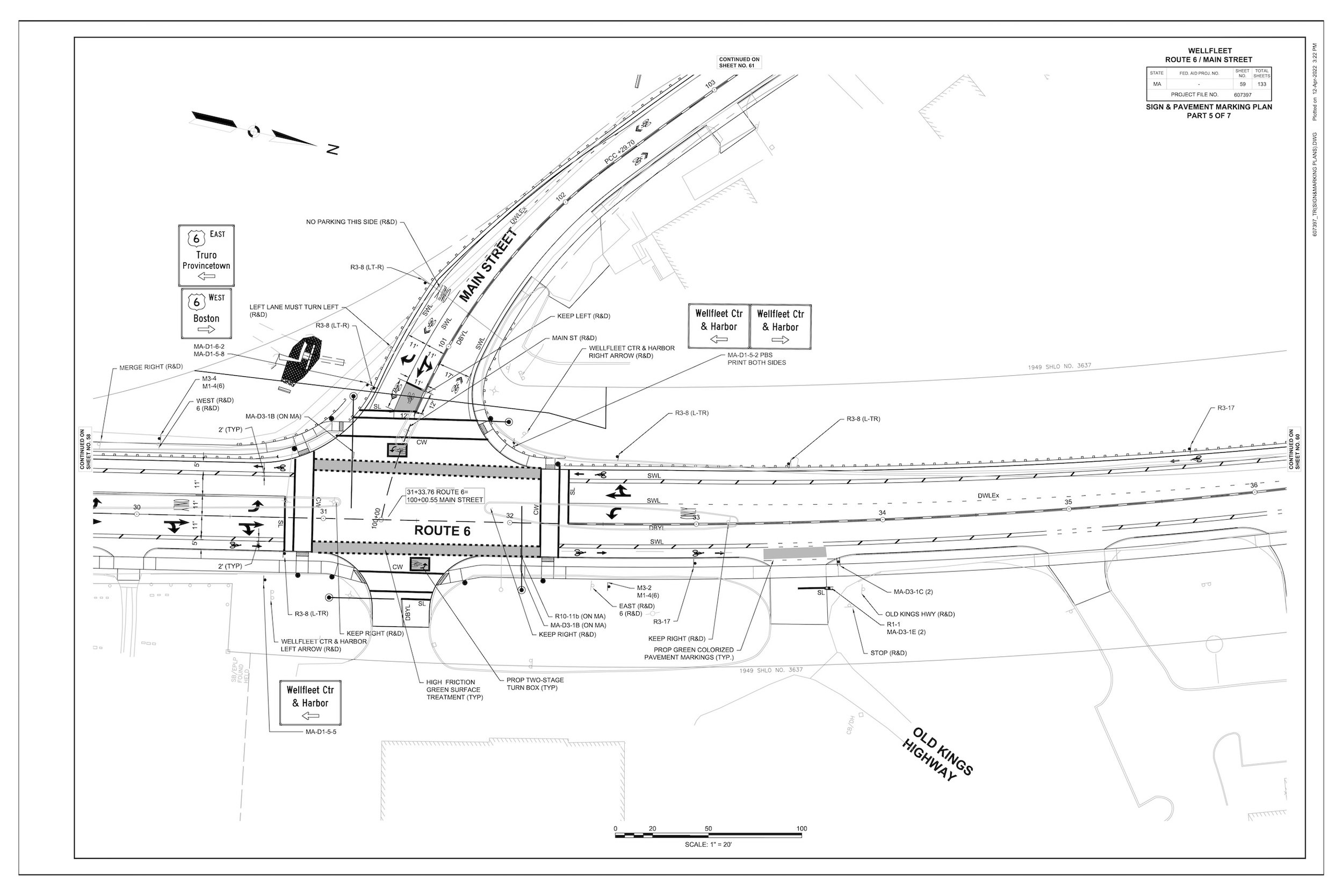
Engineering drawings are complex and detailed, so I always jump to the signage and pavement marking plan. They give the best sense of what the final project will look like. Here’s the plan I’ll be dissecting:

It’s pretty much what you’d expect based on the text description from the public hearing. Some sidewalks, crosswalks, and bike lanes.
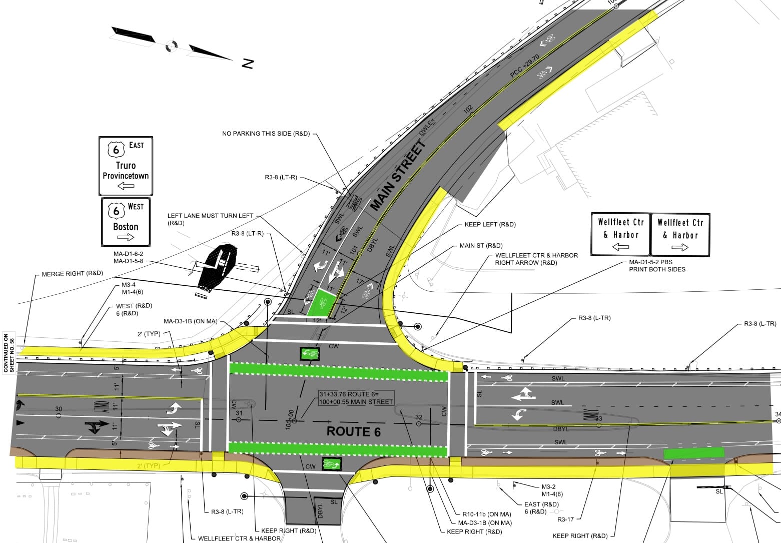
Then I zoomed in and added some color to differentiate the separate elements. Grey is asphalt, yellow is sidewalks, brown is the landscape buffer, green are the bike markings (which will actually be painted green in the plan), and white are all the assorted pavement markings such as arrows, stop lines, and crosswalks.
It’s hard to see in plan view, but there will be huge traffic light poles with long arms across the roadway (they’re the black dots and lines at the corners).
The driveway to the Outer Cape Health pharmacy is turned into a street in this plan. It gets its own traffic signal and turn lanes. The design is very suburban stroad strip mall. The pharmacy has a drive-thru, so it attracts a lot of car traffic. It also has a second curb cut further to the right for another driveway to exit pharmacy.

This looks much better for biking, but it’s not really.
Traffic Signals
The traffic signals don’t include signals for bikes. The green boxes with bikes in them means that everyone riding a bike is expected to merge in with car traffic.
Intersections like this are dangerous for people on bikes. Two of the most common crash types are know as “right hook” and “left hook” crashes. These are when a driver is turning and a person on a bike is traveling straight ahead. The driver doesn’t see the person on the bike, and they crash right into them.
So MassDOT uses those green bike boxes to try to show folks where they should stop to turn. I’d feel really exposed to oncoming cars waiting in one, and I’d likely just use the crosswalk. This is not a comfortable or all-ages-and-abilities scheme.
Speed
Main St is 30 MPH and Route 6 is 50 MPH.
All of the bike infrastructure guidance (NACTO, FHWA, MassDOT) tells engineers to build standard bike lanes on 30 MPH streets and fully separated bike lanes (with vertical separation from the road, not just paint) on 50 MPH roads. This project doesn’t meet those standards. When those bike facilities aren’t provided, the street needs to be enginnered to a lower speed and traffic calmed to bring the street down to 25 MPH or less. That’s not happening here, either.
When the light is green, that means drivers will be going at or near that max speed.
Buffered Bike Lanes
These are a weird in-between type of bike lane. It’s not a narrow standard one, and it’s not a separated lane away from the car lanes. In lots of places where these are striped, they end up with flex posts in them to keep cars out. They are ugly and uncomfortable to ride in. Typically they are used as temporary bike lanes until a vertically separated lane can be. built in the future, not as a permanent solution for a multimillion dollar road project.
In this project, it also would have made sense to put the bike lane next to the sidewalk behind the landscape buffer.

What would be a safer design?
Protected intersections are the state of the art design for intersections like this. They physically separate people on bikes from motor vehicles, help eliminate right- and left-hook crashes, and make people on bikes much more visible to drivers. In my next post, I’ll show how this intersection could have been designed this way.
Resources
- Wellfleet’s Rail Trail Extension Project Update, Pedal Ptown, March 11, 2020.
- Route 6/Main Street Intersection Project Contract Drawing Plan Set, April 2022, Town of Wellfleet, accessed on October 20, 2023.
- WELLFLEET- INTERSECTION IMPROVEMENTS & RELATED WORK AT ROUTE 6 & MAIN STREET, MassDOT, accessed on October 20, 2023.
- Wellfleet - Route 6 & Main Street Intersection Improvements - Combined design public hearing, MassDOT, accessed on October 20, 2023.
- Town of Wellfleet Road Safety Audit Route 6 at Main Street (PDF), June 2016, Cape Cod Commission, accessed on October 20, 2023.
- Main St at Route 6 in Wellfleet, Google Streetview (October 2022 images)
- Ghost Bike at Route 6 and Way 68 in Wellfleet, Google Streetview (October 2022 images)
- Common Crashes Between Bicyclists And Drivers, League of American Bicyclists, Youtube video, May 1, 2022
- Choosing an All Ages & Abilities Bicycle Facility, Urban Bikeway Design Guide, NACTO, accessed on October 20, 2023.
- Bikeway Selection Guide, FHWA, February 2019.
- MassDOT Separated Bike Lane Planning & Design Guide, Chapter 2 (PDF), MassDOT, 2015.
