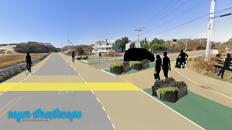
Reimagining Province Lands Road at Bradford Street Extension

This 1950s-era former state road has never been updated to provide any space for walking and biking.
It’s a beautiful location along the tidal marsh and connects the rotary at Commercial Street to the Moors Road entrance to the Province Lands in the Cape Cod National Seashore. (Google Map)
These improvements could be made today with no construction – just paint and planters.
Reimagining the intersection of Province Lands Rd and Bradford St Extension in Provincetown, MA.
Elements used in this sketch:
- Advisory lanes
- Provincetown-standard high-visibility yellow crosswalk
- Bicycle crossing
- Separated shared bike/walk/roll lanes
Materials needed to implement:
- Paint
- Planters
- A park bench.
Existing conditions:
- 22 ft to 30+ ft variable pavement width - one travel lane in each direction
- Wide turn lanes to/from Bradford St Extension
- Sand shoulders
- Metal guardrail
- 25 MPH posted speed limit.
Daily traffic volumes:
The Cape Cod Commission last counted motor vehicles at this intersection in 2018. These counts are considered “low volume” by traffic engineers:
- Northbound: 1,577 average annual daily traffic (AADT); peak 197 per hour
- Southbound: 986 average annual daily traffic (AADT); peak 110 per hour.
The nearest counts of people not in cars is from 2014 and took place just north of here on Moors Rd at Herring Cove Beach:
- Northbound: 816 total people on bikes, walking, jogging, and in wheelchairs;
- Southbound: 543 total people on bikes, walking, jogging, and in wheelchairs.
